Memory Lane – Ward 1F
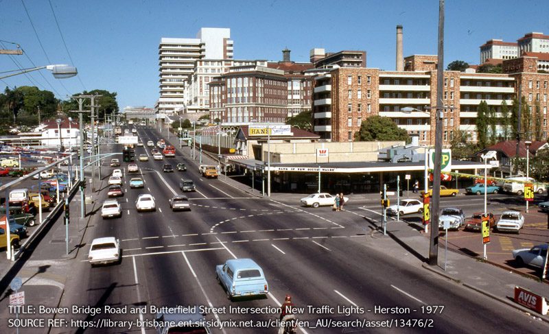
Bowen Bridge Road and Butterfield Street intersection new traffic lights, Herston – 1977
Turrbal Country
Source: Brisbane City Archives
One of the main landmarks in the suburb is the Royal Brisbane Hospital. In January 1867 Brisbane’s hospital was moved from its former site in North Brisbane (today’s central business district) to its present location in Herston. Sister Kenny, famous for her treatment of polio, operated from Ward 7 of the Brisbane Hospital. A surviving building from the hospital’s early days is the old Wardsmen’s Building which was originally used as the fever hospital. From History of Royal Brisbane and Women’s Hospital.
Construction of the old Royal Women’s Hospital commenced in 1936, opening in 1938. It was demolished in 2002 to make way for the Ned Hanlon Building, Dr James Mayne Building and Joyce Tweddell Building.
Today, the Royal Brisbane and Women’s Hospital is a 1000 bed quaternary and tertiary referral teaching hospital with a number of specialities including medicine, surgery, orthopaedics, psychiatry, oncology, trauma, obstetrics, gynaecology, gynae-oncology, urogynaecology, neonatology and community based / client-oriented education services and women’s health services. The RBWH is the largest tertiary referral hospital in Queensland and provides services to patients from throughout the State, New South Wales, Northern Territory and from neighbouring countries in the South West Pacific. The hospital fulfils a significant teaching and research role with links to Queensland’s major tertiary institutions.
Source: State Library Of Queensland
In 1859, Robert Herbert, Queensland’s first premier and his friend and colleague John Bramston, a lawyer who later became Attorney-General, bought land on a ridge to the west of Bowen Bridge Road, on the town side of the creek. They built a stone house and established a farm, which was to give that area bounded by Bowen Bridge Road, Breakfast Creek, Herston Road, L’estrange Terrace, Victoria Park Road and Gilchrist Avenue the name of Herston. Herston is the combination of the first and last parts of their surnames – Herbert and Bramston. Butterfield Street, Herston honours William Edward Butterfield, who was an early schoolmaster and journalist.
One of the main landmarks in the suburb is the Royal Brisbane Hospital. In January 1867 Brisbane’s hospital was moved from its former site in North Brisbane (today’s central business district) to its present location in Herston. Sister Kenny, famous for her treatment of polio, operated from Ward 7 of the Brisbane Hospital. A surviving building from the hospital’s early days is the old Wardsmen’s Building which was originally used as the fever hospital.
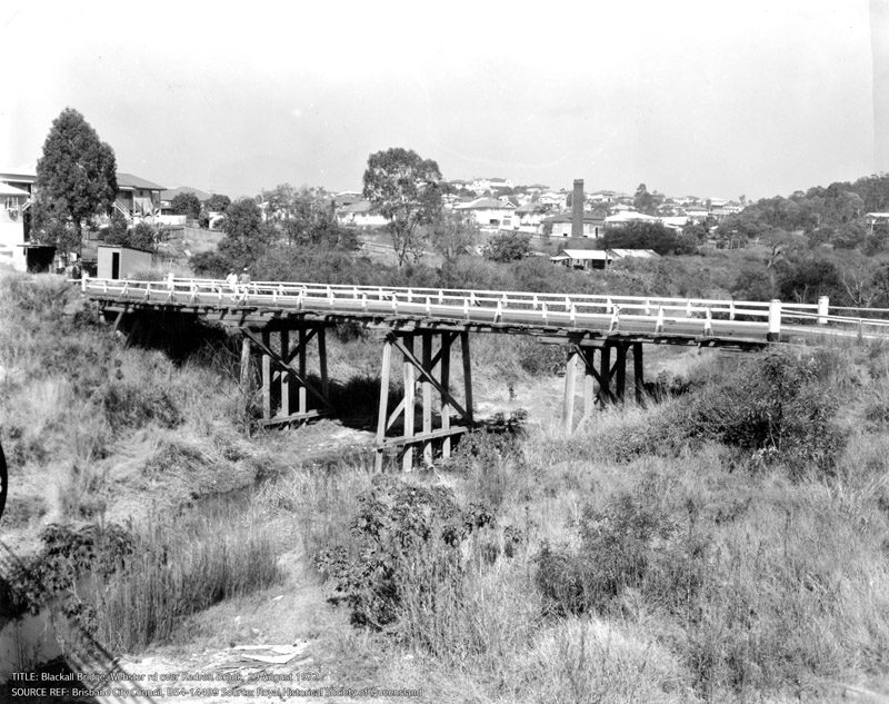
Webster Road over Kedron Brook
Turrbal Country
The first bridge built over Kedron Brook in 1870 was named after Governor Samuel Wensley Blackall who arrived in Brisbane in 1868 and died in 1871; he is buried in the Toowong Cemetery. This bridge on Webster Road improved access between Happy Valley (Stafford) and Brisbane. In 1908 a second bridge was built which fostered communication and trade between Stafford and Grange, promoting the sheep and cattle industry of the area. A third bridge was built upstream in the 1920s, by which time there were industries such as tanneries, a wool scour, dairies, a fellmongery, quarry and brick works which caused run-off into Kedron Brook. The brickworks chimney can be seen off-centre to the right in this photograph.
In March 1951 it was announced that a larger and longer bridge over Kedron Brook was planned which would eliminate the ‘S’ bend on Webster Road. A pre-stressed concrete bridge was constructed in 1959 beside the timber structure seen in this photograph. The timber bridge remained in place until the 1959 bridge was widened to four lanes in the 1980s. The ‘S’ bend caused traffic delays in the 1970s and the area ¼’.as severely flooded in the 1974 flood.
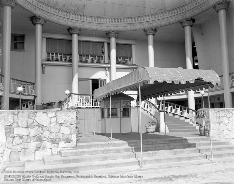
Cloudland, Bowen Hills – 1940
Turrbal Country
Originally called Luna Park and intended as a fun park, the building was constructed in 1939-40. It opened in 1940, along with a funicular railway (dismantled in 1967) to take patrons up the hill from Breakfast Creek Road. Used by the US Army during World War II, the name changed to Cloudland Ballroom when it re-opened after the war.
On a commanding hilltop site, Cloudland’s distinctive roof arch, nearly 18 metres high, was visible for miles and was illuminated at night. The interior was famous for its elegant decoration and a sprung dance floor which had huge metal coil springs placed uniformly underneath the bearers. There were private alcoves and an upper circle of tiered seating which overlooked the floor and the stage. It was considered to be one of finest ballrooms in Australia,
Cloudland was significant as a landmark, and as a place where generations of Brisbane residents went for entertainment. Thousands of dances and concerts were held there from the 1950s to the 1970s. On public holidays and significant dates or long weekends, midnight-to-dawn dances were held with resident bands. Famous guest artists included the Bee Gees and Little Pattie. For some years, The University of Queensland held annual student examinations at Cloudland.
Despite strenuous calls for its preservation, the building was demolished overnight on 7 November 1982 and an apartment complex built on the site.
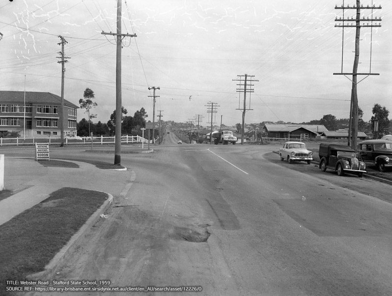
Webster/Stafford Rds, Stafford State School – 1959
Turrbal Country
From Queensland Heritage Register. Queensland Heritage Council. Retrieved 1 August 2014.
Stafford State School was constructed in 1948-49, providing primary education to children of the Stafford district. Stafford State School also incorporates formal gardens in the foreground of the school and large open playing fields to the rear of the building, established at the same time as the principal school building.
Stafford’s original name was Happy Valley until 1886, when a government administrator questioned whether such a name was dignified enough to grace a new school. It is one of the few places in Queensland which takes its suburban name from the school. Happy Valley incorporated the suburbs now known as Everton Park and Stafford, and remained a semi-rural area well into the twentieth century. Local industry included tanneries, fellmongers and dairy farms. In 1886, a simple timber school building and teacher’s residence were constructed on the original Collier Street site. This site later became Stafford State Pre-school.
From: Queensland Places
Access between Brisbane and Happy Valley improved in 1870 when the Blackall bridge was built on Webster Road to cross Kedron Brook. A quarry and brickworks were also operative by the 1880s, and it is supposed that the association of Stafford, UK with clay products may have inspired the change of name of the district. In any event, in 1886 when the post office and a school in Collier Street were opened, they were named Stafford, and Happy Valley Road was named Stafford Road.
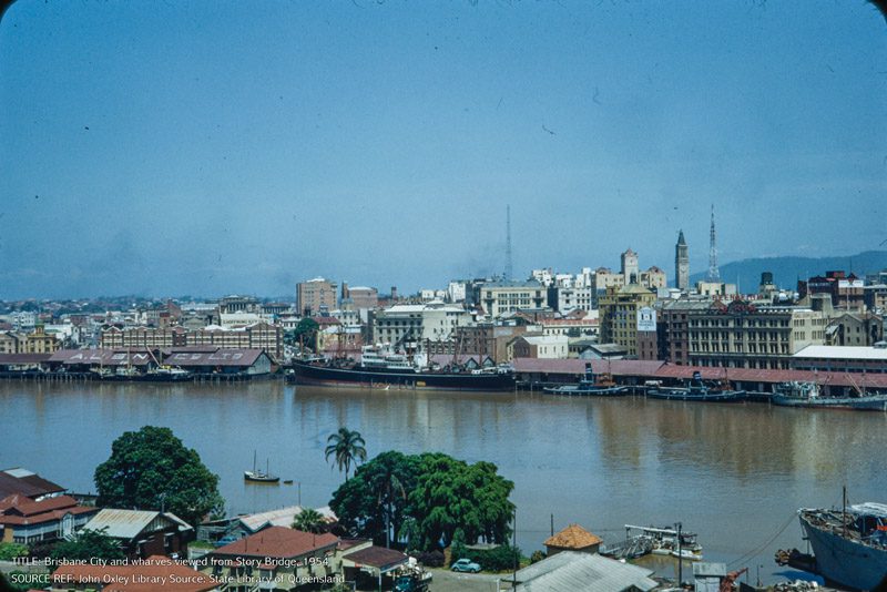
Brisbane city and wharves viewed from Story bridge, 1954
Yugara and Jagera Country
Love, Lovf Family collection 1910-1983. “The collection consists predominantly of colour slides, taken during the 1950s and 1960s of Brisbane City buildings, bridges, churches, festival and commemorative parades and Christmas celebrations. It also includes pencil sketches, some of political figures from the 1920’s, newspaper cuttings, and several black and white photographs, gathered from the estate of Alexander Henry Love.”
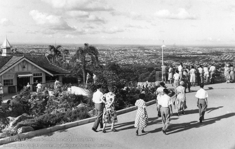
City of Brisbane from Mount Coot-tha Lookout – 1953
The panoramic views of Brisbane from the Lookout have attracted residents and visitors alike to Mount Coot-tha for well over 100 years. Although the site and its usage have seen many changes, some structures have remained such as the kiosk building on the left in the photograph, which evolved from a structure built around 1918 and which was heritage listed in 1995.
By the early 1870s, persistent logging had almost denuded the hill of vegetation and it became known locally as ‘One-Tree Hill’. In 1880, the name was changed to Mount Coot-tha (from an Aboriginal word ‘kuta’ meaning place of honey) when the area was proclaimed a recreational reserve. By the late 1880s, a shelter shed, water tanks, fireplaces and picnic tables had been constructed. In 1906, the caretaker’s wife, who lived in a cottage at the gates, opened a small kiosk next to the shelter shed, hung it with plants and set up tables and chairs inside. She brewed tea on an open fire outside the kiosk, and sold refreshments to visitors. By 1912, a drinking fountain and small timber kitchen had been added to the site. This was extended in 1918 when the Trustees of the Reserve built a larger, open-sided kiosk, forming the basis of the structure in the photograph. Extensions and alterations occurred following new designs in 1928 and 1949. These included kitchen and accommodation wings, sliding timber sash windows, the fleche and chimney visible on the kiosk roof, and the town water supply was extended to a high-level water tank. The enlarged kiosk reflected the increasing popularity and visitor numbers to Mt Coot-tha, and the proliferation of motor transport.
In 1950, there were further alterations and additions designed and supervised by Brisbane City Architect, FG Costello. He introduced the kiosk’s distinctive terra¬ cotta roof tiles and was responsible for the overall layout of the viewing area, with a raised viewing platform and a direction finder. A small viewing gazebo built in 1918 and described as having an ogee-shaped roof, stone base, open balustrades and an entrance pergola, was demolished.
Although the 1930s Depression brought spending cuts for maintenance, electricity was extended to the top of the mountain in 1935 and men working on unemployment relief improved the roads. Brisbane City Council turned a blind eye to the shanties of unemployed people, including a settlement built of kerosene tins and hessian just outside the reserve’s gates.
During World War II, the US Seventh Fleet established an ammunition depot on the Mount Coot-tha Reserve and anti-aircraft guns and searchlight units were located at the summit, one near the lookout. There was a small zoo, said to be a favourite with the son of General Douglas MacArthur. In 1947, Mount Coot-tha became a communications centre for the Postmaster-General’s Department (PMG) and, after 1961, the location for television station towers.
Despite changes over the years, Mount Coot-tha retains a significant area of bush reserve, including the Brisbane Botanic Gardens at its base. Access to the lookout and the spectacular views remains unchanged.
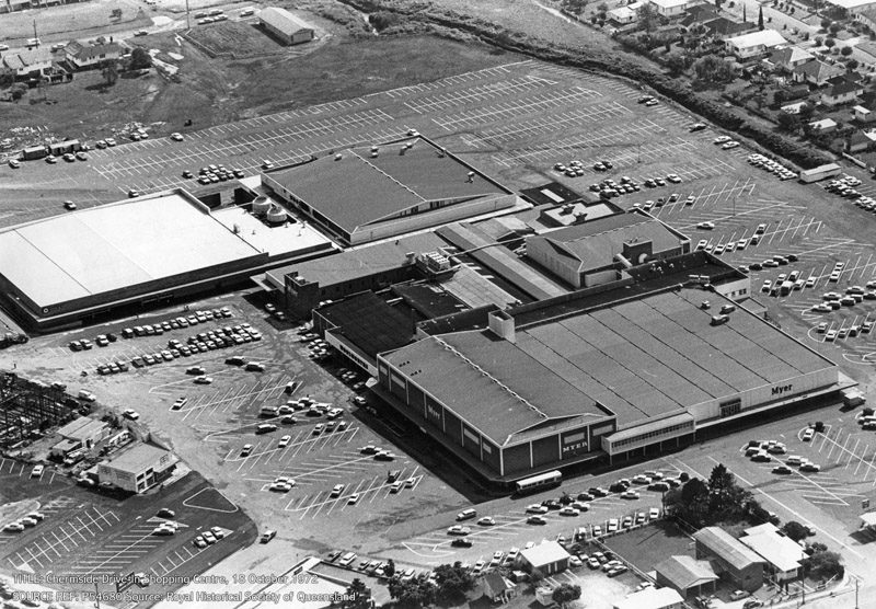
Chermside Drive-in Shopping Centre, 18 October 1972
Turrbal Country
Situated on the corner of Gympie and Hamilton Roads, the centre (now Westfield Chermside) was marketed as the first suburban-style, post-war shopping precinct in the southern hemisphere when it was opened by Premier Vince Gair on 31 May 1957. Eager to snap up opening bargains, an estimated 15,000 shoppers arrived for the opening and porters were employed to carry purchases to shoppers’ cars. Initially the complex included an Allan & Stark Department Store (Myer from 1959), a cash and carry supermarket, 24 specialty shops, parking for 650 cars and covered 28 acres (11 hectares).
Westfield bought the complex from Coles-Myer in 1996 and in 1999 another redevelopment doubled the floor space and a new bus interchange was built. In 2000 an expansion included a 900 seat food court and a Birch Carroll & Coyle Cinema complex.
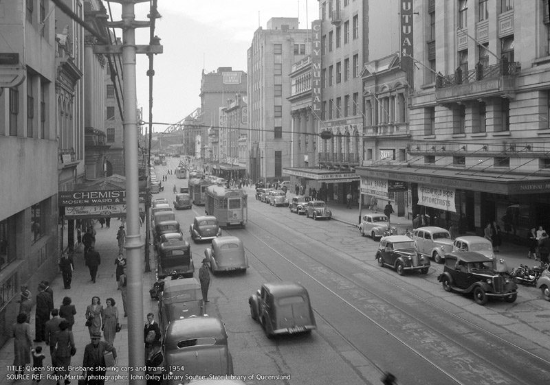
Queen Street, Brisbane, showing cars and trams – 1954
A tram bound for the South Brisbane Railway Station is heading towards the Victoria Bridge. Pedestrians are in the fashions of the 1950s; men wear felt hats and some women are ‘dressed up’ for their trip to the city in hats, gloves and below-knee dresses. To the left is the Australian Hotel and in the distance is the Australian Mutual Life (AML) Insurance building. Signage is clearly displayed on three cinemas, the Wintergarden (1924-1981), the Odeon (1952-1981) and the Regent (1929-2010).
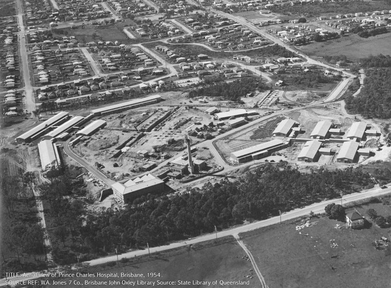
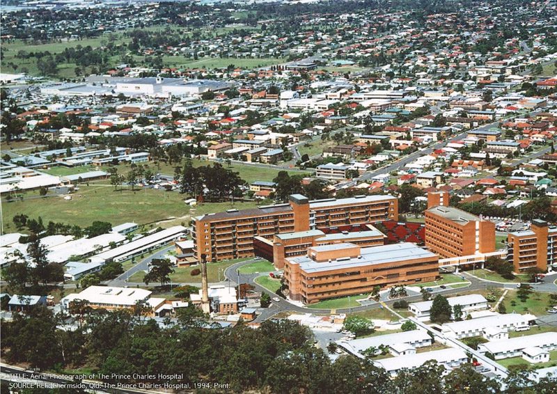
The Prince Charles Hospital – 1954 and 1994
Turrbal Country
In 1954 a multi-story main building, nurses’ home block and administration block were officially opened on the 13th September. The main building could accommodate 412 beds and the nurses’ block accommodated eight medical officers, the Matron, the Deputy Matron and 152 nurses in separate rooms, with built-in furniture and hot and cold water. The first of the three prefabricated wards (“Bristols”) was occupied on the 16th August.
The Brisbane Chest Hospital officially opened on the 14th November as a purpose built Tuberculosis (TB) Sanatorium with three pre-fabricated wards providing 186 beds.
1994: The Prince Charles Hospital Health Service District was established December and Queensland’s first paediatric heart transplant was performed.